added 127 characters in body
Source Link
sempaiscuba
  • 5.2k
  • 2
  • 15
  • 34

The best match that I could find is 'Shemetitsa' from the JewishGen Gazetteer.

It is listed as a 'populated place' with coordinates 51° 03'N 28° 26'E, which would place it within the Volhynian governorate in the north of modern Ukraine, about 2km SE of Luhyny.

I've looked for it with a number of online maps, including mapcarta, and Google Maps and there doesn't seem to be much there today.

Mapire have an historical map of the area around Luhyny. The map doesn't have a scale, and the place names use a Cyrillic script (plus the tape joining the sections of the map is irritating), but there is a settlement to the south-east of Luhyny that may be Shemetitsa.
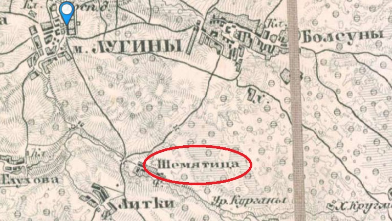
map

What's written on the card may be an attempt to 'Anglicise' the place name to allow it to be written in the Latin alphabet.

The best match that I could find is 'Shemetitsa' from the JewishGen Gazetteer.

It is listed as a 'populated place' with coordinates 51° 03'N 28° 26'E, which would place it within the Volhynian governorate in the north of modern Ukraine, about 2km SE of Luhyny.

I've looked for it with a number of online maps, including mapcarta, and Google Maps and there doesn't seem to be much there today.

Mapire have an historical map of the area around Luhyny. The map doesn't have a scale, and the place names use a Cyrillic script (plus the tape joining the sections of the map is irritating), but there is a settlement to the south-east of Luhyny that may be Shemetitsa.

map

What's written on the card may be an attempt to 'Anglicise' the place name to allow it to be written in the Latin alphabet.

Source Link
sempaiscuba
  • 5.2k
  • 2
  • 15
  • 34

The best match that I could find is 'Shemetitsa' from the JewishGen Gazetteer.

It is listed as a 'populated place' with coordinates 51° 03'N 28° 26'E, which would place it within the Volhynian governorate in the north of modern Ukraine, about 2km SE of Luhyny.

I've looked for it with a number of online maps, including mapcarta, and Google Maps and there doesn't seem to be much there today.

Mapire have an historical map of the area around Luhyny. The map doesn't have a scale, and the place names use a Cyrillic script (plus the tape joining the sections of the map is irritating), but there is a settlement to the south-east of Luhyny that may be Shemetitsa.

map