edited body
Source Link
Harry V.
  • 18.9k
  • 5
  • 47
  • 101

Generally, you can use whatever naming practice you want to if you're working on your own. If you're cooperating with someone, it's obviously best to agree on some common standard, but that's between you and the others working on the project and nobody from the outside has any business or right to tell you what is the "right" or "wrong" way to name places.

This also applies to the decision if you want to use the current political structure or the place hierarchy at the time of the event. Decide on one approach, document it if you're working with a team, and stick to it. Both have their strength and weaknesses, so it's best to use them both in parallel where possible, but this is seldom the case. The GEDCOM data format for example doesn't have any capability of recording place hierarchy changes over time since places aren't top-level elements of it.

In the specific case of the USA, I'd keep the "County" part to distinguish place names like these from each other:

This also answers your second question: There are indeed places in the USA where counties do not exist. In particular, Washington, D.C. is not even part of any state and there are 41 independent cities which don't belong to any county.

On the other hand, there are "cities" or metropolises which are spread across multiple counties; you'll have to keep that in mind as well with whatever hierarchy you'll end up using. One example would be New York City, consisting of:

  • Bronx County, New York, USA
  • Kings County, New York, USA (Brooklyn)
  • New York County, New York, USA (Manhattan)
  • Queens County, New York, USA
  • Richmond County, New York, USA (Staten Island)

There are also places which politically belong to one county, while geographically being split between multiple of them. One example is Bothell, KingsKing County, Washington, USA which is geographically nearly halfway in SonomishSnohomish County, Washington, USA (designated in red in the picture).
enter image description here

The term "county" is used in 48 of the US states, the two exceptions being Alaska and Louisiana. Alaska's equivalents are organised boroughs (plus one unorganised borough), while Louisiana uses parishes. Federal terminology refers to Louisiana parishes, Alaskan boroughs and independent cities as "county equivalents".

Generally, you can use whatever naming practice you want to if you're working on your own. If you're cooperating with someone, it's obviously best to agree on some common standard, but that's between you and the others working on the project and nobody from the outside has any business or right to tell you what is the "right" or "wrong" way to name places.

This also applies to the decision if you want to use the current political structure or the place hierarchy at the time of the event. Decide on one approach, document it if you're working with a team, and stick to it. Both have their strength and weaknesses, so it's best to use them both in parallel where possible, but this is seldom the case. The GEDCOM data format for example doesn't have any capability of recording place hierarchy changes over time since places aren't top-level elements of it.

In the specific case of the USA, I'd keep the "County" part to distinguish place names like these from each other:

This also answers your second question: There are indeed places in the USA where counties do not exist. In particular, Washington, D.C. is not even part of any state and there are 41 independent cities which don't belong to any county.

On the other hand, there are "cities" or metropolises which are spread across multiple counties; you'll have to keep that in mind as well with whatever hierarchy you'll end up using. One example would be New York City, consisting of:

  • Bronx County, New York, USA
  • Kings County, New York, USA (Brooklyn)
  • New York County, New York, USA (Manhattan)
  • Queens County, New York, USA
  • Richmond County, New York, USA (Staten Island)

There are also places which politically belong to one county, while geographically being split between multiple of them. One example is Bothell, Kings County, Washington, USA which is geographically nearly halfway in Sonomish County, Washington, USA (designated in red in the picture).

enter image description here

The term "county" is used in 48 of the US states, the two exceptions being Alaska and Louisiana. Alaska's equivalents are organised boroughs (plus one unorganised borough), while Louisiana uses parishes. Federal terminology refers to Louisiana parishes, Alaskan boroughs and independent cities as "county equivalents".

Generally, you can use whatever naming practice you want to if you're working on your own. If you're cooperating with someone, it's obviously best to agree on some common standard, but that's between you and the others working on the project and nobody from the outside has any business or right to tell you what is the "right" or "wrong" way to name places.

This also applies to the decision if you want to use the current political structure or the place hierarchy at the time of the event. Decide on one approach, document it if you're working with a team, and stick to it. Both have their strength and weaknesses, so it's best to use them both in parallel where possible, but this is seldom the case. The GEDCOM data format for example doesn't have any capability of recording place hierarchy changes over time since places aren't top-level elements of it.

In the specific case of the USA, I'd keep the "County" part to distinguish place names like these from each other:

This also answers your second question: There are indeed places in the USA where counties do not exist. In particular, Washington, D.C. is not even part of any state and there are 41 independent cities which don't belong to any county.

On the other hand, there are "cities" or metropolises which are spread across multiple counties; you'll have to keep that in mind as well with whatever hierarchy you'll end up using. One example would be New York City, consisting of:

  • Bronx County, New York, USA
  • Kings County, New York, USA (Brooklyn)
  • New York County, New York, USA (Manhattan)
  • Queens County, New York, USA
  • Richmond County, New York, USA (Staten Island)

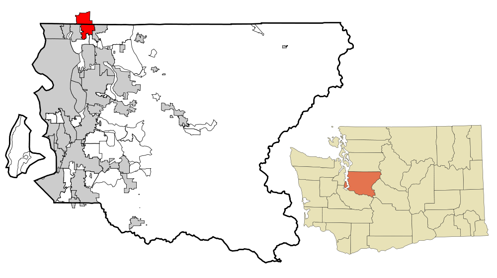
There are also places which politically belong to one county, while geographically being split between multiple of them. One example is Bothell, King County, Washington, USA which is geographically nearly halfway in Snohomish County, Washington, USA (designated in red in the picture).

enter image description here

The term "county" is used in 48 of the US states, the two exceptions being Alaska and Louisiana. Alaska's equivalents are organised boroughs (plus one unorganised borough), while Louisiana uses parishes. Federal terminology refers to Louisiana parishes, Alaskan boroughs and independent cities as "county equivalents".

Add paragraph re Alaska and Louisiana being the two states not to use counties. (Citing Wikipedia).
Source Link
AdrianB38
  • 11.8k
  • 23
  • 37

Generally, you can use whatever naming practice you want to if you're working on your own. If you're cooperating with someone, it's obviously best to agree on some common standard, but that's between you and the others working on the project and nobody from the outside has any business or right to tell you what is the "right" or "wrong" way to name places.

This also applies to the decision if you want to use the current political structure or the place hierarchy at the time of the event. Decide on one approach, document it if you're working with a team, and stick to it. Both have their strength and weaknesses, so it's best to use them both in parallel where possible, but this is seldom the case. The GEDCOM data format for example doesn't have any capability of recording place hierarchy changes over time since places aren't top-level elements of it.

In the specific case of the USA, I'd keep the "County" part to distinguish place names like these from each other:

This also answers your second question: There are indeed places in the USA where counties do not exist. In particular, Washington, D.C. is not even part of any state and there are 41 independent cities which don't belong to any county.

On the other hand, there are "cities" or metropolises which are spread across multiple counties; you'll have to keep that in mind as well with whatever hierarchy you'll end up using. One example would be New York City, consisting of:

  • Bronx County, New York, USA
  • Kings County, New York, USA (Brooklyn)
  • New York County, New York, USA (Manhattan)
  • Queens County, New York, USA
  • Richmond County, New York, USA (Staten Island)

There are also places which politically belong to one county, while geographically being split between multiple of them. One example is Bothell, Kings County, Washington, USA which is geographically nearly halfway in Sonomish County, Washington, USA (designated in red in the picture).

enter image description here

The term "county" is used in 48 of the US states, the two exceptions being Alaska and Louisiana. Alaska's equivalents are organised boroughs (plus one unorganised borough), while Louisiana uses parishes. Federal terminology refers to Louisiana parishes, Alaskan boroughs and independent cities as "county equivalents".

Generally, you can use whatever naming practice you want to if you're working on your own. If you're cooperating with someone, it's obviously best to agree on some common standard, but that's between you and the others working on the project and nobody from the outside has any business or right to tell you what is the "right" or "wrong" way to name places.

This also applies to the decision if you want to use the current political structure or the place hierarchy at the time of the event. Decide on one approach, document it if you're working with a team, and stick to it. Both have their strength and weaknesses, so it's best to use them both in parallel where possible, but this is seldom the case. The GEDCOM data format for example doesn't have any capability of recording place hierarchy changes over time since places aren't top-level elements of it.

In the specific case of the USA, I'd keep the "County" part to distinguish place names like these from each other:

This also answers your second question: There are indeed places in the USA where counties do not exist. In particular, Washington, D.C. is not even part of any state and there are 41 independent cities which don't belong to any county.

On the other hand, there are "cities" or metropolises which are spread across multiple counties; you'll have to keep that in mind as well with whatever hierarchy you'll end up using. One example would be New York City, consisting of:

  • Bronx County, New York, USA
  • Kings County, New York, USA (Brooklyn)
  • New York County, New York, USA (Manhattan)
  • Queens County, New York, USA
  • Richmond County, New York, USA (Staten Island)

There are also places which politically belong to one county, while geographically being split between multiple of them. One example is Bothell, Kings County, Washington, USA which is geographically nearly halfway in Sonomish County, Washington, USA (designated in red in the picture).

enter image description here

The term "county" is used in 48 of the US states, the two exceptions being Alaska and Louisiana. Alaska's equivalents are organised boroughs (plus one unorganised borough), while Louisiana uses parishes. Federal terminology refers to Louisiana parishes, Alaskan boroughs and independent cities as "county equivalents".

added 495 characters in body
Source Link

Generally, you can use whatever naming practice you want to if you're working on your own. If you're cooperating with someone, it's obviously best to agree on some common standard, but that's between you and the others working on the project and nobody from the outside has any business or right to tell you what is the "right" or "wrong" way to name places.

This also applies to the decision if you want to use the current political structure or the place hierarchy at the time of the event. Decide on one approach, document it if you're working with a team, and stick to it. Both have their strength and weaknesses, so it's best to use them both in parallel where possible, but this is seldom the case. The GEDCOM data format for example doesn't have any capability of recording place hierarchy changes over time since places aren't top-level elements of it.

In the specific case of the USA, I'd keep the "County" part to distinguish place names like these from each other:

This also answers your second question: There are indeed places in the USA where counties do not exist. In particular, Washington, D.C. is not even part of any state and there are 41 independent cities which don't belong to any county.

On the other hand, there are "cities" or metropolises which are spread across multiple counties; you'll have to keep that in mind as well with whatever hierarchy you'll end up using. One example would be New York City, consisting of:

  • Bronx County, New York, USA
  • Kings County, New York, USA (Brooklyn)
  • New York County, New York, USA (Manhattan)
  • Queens County, New York, USA
  • Richmond County, New York, USA (Staten Island)

There are also places which politically belong to one county, while geographically being split between multiple of them. One example is Bothell, Kings County, Washington, USA which is geographically nearly halfway in Sonomish County, Washington, USA (designated in red in the picture).

enter image description here

Generally, you can use whatever naming practice you want to if you're working on your own. If you're cooperating with someone, it's obviously best to agree on some common standard, but that's between you and the others working on the project and nobody from the outside has any business or right to tell you what is the "right" or "wrong" way to name places.

This also applies to the decision if you want to use the current political structure or the place hierarchy at the time of the event. Decide on one approach, document it if you're working with a team, and stick to it. Both have their strength and weaknesses, so it's best to use them both in parallel where possible, but this is seldom the case. The GEDCOM data format for example doesn't have any capability of recording place hierarchy changes over time since places aren't top-level elements of it.

In the specific case of the USA, I'd keep the "County" part to distinguish place names like these from each other:

This also answers your second question: There are indeed places in the USA where counties do not exist. In particular, Washington, D.C. is not even part of any state and there are 41 independent cities which don't belong to any county.

On the other hand, there are "cities" or metropolises which are spread across multiple counties; you'll have to keep that in mind as well with whatever hierarchy you'll end up using. One example would be New York City, consisting of:

  • Bronx County, New York, USA
  • Kings County, New York, USA (Brooklyn)
  • New York County, New York, USA (Manhattan)
  • Queens County, New York, USA
  • Richmond County, New York, USA (Staten Island)

There are also places which politically belong to one county, while geographically being split between multiple of them. One example is Bothell, Kings County, Washington, USA which is geographically nearly halfway in Sonomish County, Washington, USA (designated in red in the picture).

enter image description here

added 496 characters in body
Source Link
Loading
added 508 characters in body
Source Link
Loading
Source Link
Loading